
32 public images in metropolitan Manila
American urban planner Kevin Lynch wrote: “Cities are ever changing in detail.” He studied how people put meanings in what they see in cities, and create public images, which are mental pictures shared and agreed upon by citizens to create identity.
More importantly, he looked at how they work together to become legible—or coherent—and how they elicit emotion from the people.
We usually associate iconic buildings or monuments, tourism attractions and products to define cities. But there are city elements that become building blocks to influence the imageability of a place, or in simple terms, contents of a city that imprint mental images into our experiences.
What do we share in our common ground of Metro Manila? In celebration of the Philippine Daily Inquirer’s 32nd anniversary, let’s take a random look at 32 public images within our own metropolitan, which have, in one way or another, connected us, shaped our living space, created meaning, or added coherence to the fabric and memories of our cities.
Paths
Paths are channels where we move, routes that transport us in the city.
1. While our everyday complaint is how its traffic just can’t get any worse, Epifanio delos Santos Avenue’s significance to the country stands out, and well beyond transport. The longest highway in the metro, this thoroughfare has served as a defining point of the People Power Revolution. Edsa is a part of the C-4 network, and was previously called Highway 54.
2. Before it was renamed Roxas Boulevard, it was known to be the Cavite Boulevard, a part of the great Daniel Burnham’s masterplan of Manila. Today, we encounter many of Manila’s historic sites as we traverse this path: the CCP Complex, the Senate, Rizal Park, the Manila Hotel, famous museums, foreign embassies, and maritime schools.
3. Commonwealth Avenue is one of the metro’s major roads in Quezon City. On its borders are UP Diliman, the Quezon Memorial Circle, and Sandiganbayan, among other iconic public images. Sadly, it is also infamous for being a killer thoroughfare because of its high accident rate.
4. C-5, or Carlos P. Garcia Avenue, services the east and central metropolitan areas. This circumferential arterial road traverses major avenues of cities, such as Katipunan, and E. Rodriguez. It also touches popular commercial centers such as the Eastwood City, many SM establishments, and Market! Market!.
5. Smaller and shorter than other paths on the list, Mendiola Street, houses the University Belt and is known for the strong protests from students and farmers, making it a memorable and game-changing place for citizens. Its accessibility and closures are also vital to the protection of the Malacañan palace.
6. Taft Avenue connects the old streets of Manila: Libertad, Buendia, Quirino, Vito Cruz, Padre Faura, and so on. It was first known as Calle Rizal, and to date, still reminds us of our commonwealth era under the United States when William Howard Taft was president.
Edges
Edges are boundaries, barriers, or breaks in continuity.
7. The Manila Bay provides the view of our capital city, and boasts one of the most iconic sunsets in the country. While we have been pushing the shoreline and reclaiming land back and forth, history tells us of the warships on its front, and its access to Corregidor’s artillery for the defense of the country.
8. The Pasig and Marikina Rivers are technically a tidal estuary and its tributary, and have been major transport routes during the Spanish colonization. Sadly, these rivers now battle with pollution, which local authorities continue to address through rehabilitation efforts. Their riverbanks and waterfront development have thus attracted many volunteer activities and local tourism over the years.
9. Our everyday cramming experience at the MRT and LRT lines makes these edges a blessing to be thankful for and a curse to live with, if not further improved. Mass transit plays a key role in connectivity and mobility in a metro setting.
10. The Philippine National Railways (PNR) system dates back to the late 1800s. Today, it connects our metro cities with the greater areas of Mega Manila and beyond.
Districts
We characterize districts as areas where we go in and out of, sections that have distinct characteristics.
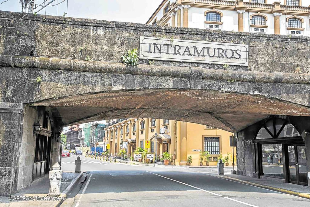
11. Intramuros is the famous Walled City of Manila, housing UNESCO heritage sites, baroque churches, and monuments that have survived the Philippine wars throughout history. Intramuros transports any local or tourist back in time, providing a glimpse of old Manila through its retained architecture and old landscape.
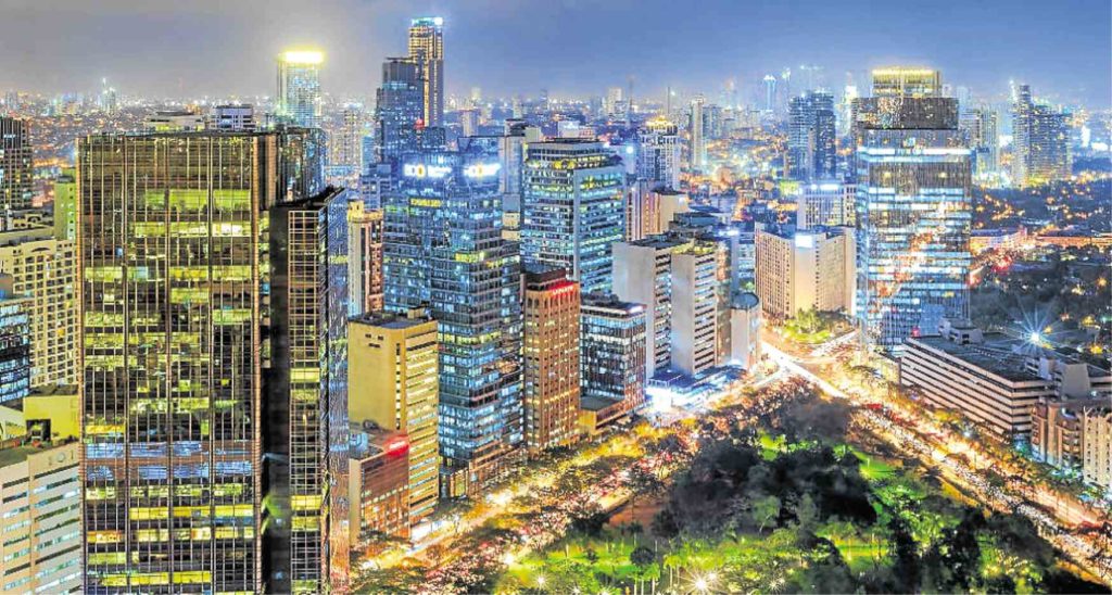
12. The Makati central business district is the financial and business district of the Philippines, with its major thoroughfare, Ayala Avenue, being called the “Wall Street” of the country. This district’s skyscrapers, which are home to the largest corporations, firms, and media, make up the famous skyline of Makati City.
13. There’s something that hits close to home when we say we’re going to Cubao. With its iconic Araneta Center in its midst, Cubao has transformed from its low-rise state to a developed commercial shopping center over the decades.
14. The Bonifacio Global City in Taguig is another leading financial district, popular for the development of Bonifacio High Street, McKinley Hill, and Forbes. This district provides a unique sense of modernity and pleasantness apart from many other areas of the metropolitan.
15. Irasan, or the Salt Beds of Las Piñas, is a small livelihood district now just in our memory. It was once known to be the origin of Primera, or the best produced salt, but issues of sewage, construction, and commercialization have led to the eventual disruption of salt production.
16. Beyond just the airport, the NAIA Complex and its vicinity provide a multitude of feelings to travelers leaving or arriving in Metro Manila, and a permanent soundtrack of airplane engine noise to nearby residents. This district is characterized by being entirely fast-paced.
17. When we think of Malabon, old heritage houses line its streets, distinct from many of the already modernized residential areas of the metropolitan. These houses have attracted photographers, conservationists, and architecture enthusiasts to the city.
18. The People’s Park of Valenzuela is fairly new, being opened to the citizens in 2015. This park champions a well developed, open, shared space that engages the public.
19. Another go-to commercial district is the Ortigas Center. Once a hacienda, it now houses business complexes, the Asian Development Bank, high-rise buildings, residences, and the famous SM Megamall.
20. Districts are not only built-up areas. The wetlands of Las Piñas and Parañaque are unique because of its own ecosystem, putting the importance of the natural environment in the forefront of an urban landscape. Efforts to preserve the swamp, mangroves, and endangered bird species have been addressed by the Las Piñas-Parañaque Critical Habitat and Eco-Tourism Area.
21. Yuppies, nightlife, luxury, and youth define Eastwood City particularly because of its business processing outsourcing complex, and its research and development base.
22. The Navotas Fishport Complex is said to be one of the largest in Asia, and operates a business center and harbour that supply tons of fish all over the metropolitan.
23. Say San Juan, and the Greenhills Shopping Center pops into mind. Bargain hunting characterizes this place, with tiangges lined row after row, overwhelming shoppers with a myriad of products, from clothes to toys and electronics.
24. We don’t usually use the name Bay City, because we associate it with the SM Mall of Asia, Solaire, Okada, and the City of Dreams. This district is the reclaimed area of Manila Bay, and runs luxurious businesses of casinos, amusement, theatres, and malls.
25. Lastly for districts, Mandaluyong is most identified by the National Center for Mental Health, and perfectly demonstrates the district as a city element, because of how we jest about “loob” and “labas.”
Nodes
Nodes are cores or strategic points which we can enter, such as junctions or crossings, a convergence of paths.
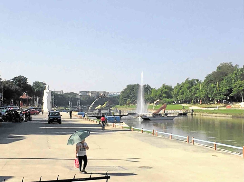
26. The Quezon Memorial Circle is actually an enclosed park with the iconic 66-meter tall mausoleum. But it is inside the famous Elliptical Road, which branches out to seven major thoroughfares: Commonwealth, Kalayaan, Quezon Ave., North Ave., East Ave., Visayas Ave. and Maharlika Street.
27. Similar to the Circle, the Bonifacio Monument, or Monumento, is encircled by a roundabout that leads to Edsa, MacArthur Highway, Avenida, and Samson Road. This decision point for the travelling and commuting public pays tribute to Andres Bonifacio, the revolution, and the Cry of Pugadlawin.
28. The Welcome Rotonda in Quezon City, connects España, E. Rodriguez Sr. Boulevard, Quezon Avenue, and Mayon Avenue. This is also called Mabuhay Rotonda because of its welcome marble monument.
Landmarks
Something we’re already familiar with, landmarks are defined as objects that serve as external point-references.
29. The Rizal Monument in Luneta is heralded as the most celebrated monument, guarded and secured 24/7, and photographed widely. This landmark pays tribute to nationalism, martyrdom, and dedication to the Filipino people.
30. The Edsa Shrine, or the Shrine of Mary, Queen of Peace, pays tribute to the peaceful and bloodless outcome of the People Power Revolution in 1986.
31. The People Power Monument, which is just a walking distance from the Edsa Shrine, is also dedicated to the bravery of Filipino people who marched fearlessly on streets against tyranny and dictatorship.
32. Lastly, the Pinaglabanan Shrine in San Juan commemorates the battle of Katipuneros against the Spanish. Our revolutionary ancestors fought guns with bolos, displaying utmost bravery in the fight against colonization.
Public images in these elements may be too common in our everyday routines.
But understanding them helps contribute to what we feel when we move up and down a street, pass by a monument, or a river, or go farther from home, which becomes smaller and smaller in a rear view mirror.
Understanding a metropolitan, outside one’s usual environment, is significant in bringing common ground to at least 15 million citizens, who bustle about in our busy cities, but share a common history, and common meanings.
The author is an environmental planner in Metro Manila. She advocates for better understanding of cities, urban management, and citizen empowerment in the Philippines. She blogs about her planning experiences at littlemissurbanite.wordpress.com.